
Thank you for supporting this site ❤️
Make a donation
Make a donation
Stormville topographic map
Click on the map to display elevation.
Thank you for supporting this site ❤️
Make a donation
Make a donation
About this map
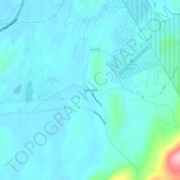
Name: Stormville topographic map, elevation, terrain.
Average elevation: 112 m
Minimum elevation: 88 m
Maximum elevation: 300 m
Thank you for supporting this site ❤️
Make a donation
Make a donation
Other topographic maps
Click on a map to view its topography, its elevation and its terrain.
Alamar Unit
United States > New York > Dutchess County > Town of East Fishkill
Average elevation: 278 m