
Thank you for supporting this site ❤️
Make a donation
Make a donation
Thuruthoor topographic map
Click on the map to display elevation.
Thank you for supporting this site ❤️
Make a donation
Make a donation
About this map
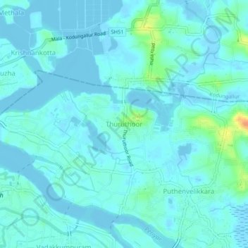
Name: Thuruthoor topographic map, elevation, terrain.
Location: Thuruthoor, Paravur, Ernakulam district, Kerala, 680733, India (10.17860 76.21516 10.21860 76.25516)
Average elevation: 5 m
Minimum elevation: -4 m
Maximum elevation: 37 m
Thank you for supporting this site ❤️
Make a donation
Make a donation
Other topographic maps
Click on a map to view its topography, its elevation and its terrain.
Valiya Pazhampilli Thuruth
India > Kerala > Paravur > Valiya Pazhampilli Thuruth
Average elevation: 5 m