
Thank you for supporting this site ❤️
Make a donation
Make a donation
Davison Township topographic map
Click on the map to display elevation.
Thank you for supporting this site ❤️
Make a donation
Make a donation
About this map
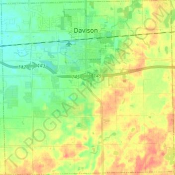
Name: Davison Township topographic map, elevation, terrain.
Location: Davison Township, Genesee County, Michigan, United States (42.96147 -83.57655 43.05001 -83.45678)
Average elevation: 250 m
Minimum elevation: 231 m
Maximum elevation: 273 m
Thank you for supporting this site ❤️
Make a donation
Make a donation
Other topographic maps
Click on a map to view its topography, its elevation and its terrain.
Genessee County Recreational Area
United States > Michigan > Genesee County > Genesee Charter Township
Average elevation: 231 m