
Klüppelberg topographic map
Interactive map
Click on the map to display elevation.
About this map
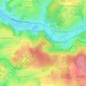
Name: Klüppelberg topographic map, elevation, terrain.
Average elevation: 335 m
Minimum elevation: 278 m
Maximum elevation: 402 m
Other topographic maps
Click on a map to view its topography, its elevation and its terrain.
Hof
Duitsland > Noordrijn-Westfalen > Oberbergischer Kreis > Wipperfürth > Thier
Hof, Thier, Wipperfürth, Oberbergischer Kreis, Noordrijn-Westfalen, 51688, Duitsland
Average elevation: 269 m
Kollenberg
Duitsland > Noordrijn-Westfalen > Oberbergischer Kreis > Wipperfürth
Kollenberg, Wipperfürth, Oberbergischer Kreis, Noordrijn-Westfalen, 51689, Duitsland
Average elevation: 298 m