
Make a donation
Visoko topographic map
Click on the map to display elevation.
Make a donation
Visoko
The Visoko municipality covers 232 square kilometres with several characteristic, morphologically distinctive valleys formed by the foothills of the Central Bosnian mountains including Ozren, Vranica and Zvijezda. The altitude of the region ranges from 400 to 1,050 metres. Visoko's natural environment is defined by the river-valleys of the Bosna and Fojnica rivers which converge near the town. The Bosna River, one of the country’s main waterways, flows northward through the municipality and historically provided trade and transport links. The Fojnica River, a tributary, further shaped the fertile basin around the settlement. Numerous smaller streams and creeks descend from the hills, contributing to a relatively dense hydrographic network. The municipality borders the towns of Kiseljak, Busovača, Kakanj, Vareš, Breza, Ilijaš and Ilidža. The climate of Visoko is continental, with moderately cold winters and warm summers, influenced by its inland location and surrounding mountains.
Make a donation
About this map
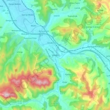
Name: Visoko topographic map, elevation, terrain.
Average elevation: 527 m
Minimum elevation: 399 m
Maximum elevation: 840 m
Make a donation