
Thank you for supporting this site ❤️
Make a donation
Make a donation
Prunedale topographic map
Click on the map to display elevation.
Thank you for supporting this site ❤️
Make a donation
Make a donation
Prunedale
Prunedale is a census-designated place in Monterey County, California. Prunedale is located 8 miles (13 km) north of Salinas, at an elevation of 92 feet (28 m). The population was 17,560 residents at the time of the 2010 census, up from 16,432 at the 2000 census. Plum trees were grown in Prunedale in the early days of its founding but the trees died soon after due to poor irrigation and fertilizer.
Thank you for supporting this site ❤️
Make a donation
Make a donation
About this map
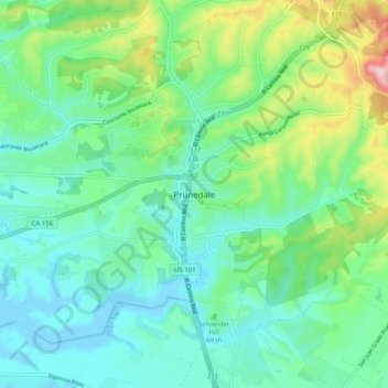
Name: Prunedale topographic map, elevation, terrain.
Average elevation: 69 m
Minimum elevation: -8 m
Maximum elevation: 275 m
Thank you for supporting this site ❤️
Make a donation
Make a donation