
Thank you for supporting this site ❤️
Make a donation
Make a donation
Gulf Summit topographic map
Click on the map to display elevation.
Thank you for supporting this site ❤️
Make a donation
Make a donation
About this map
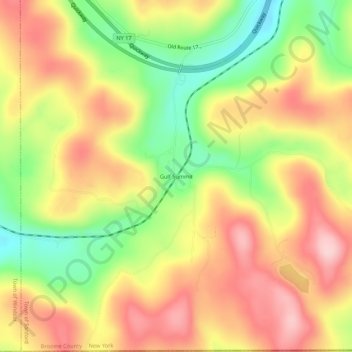
Name: Gulf Summit topographic map, elevation, terrain.
Average elevation: 479 m
Minimum elevation: 362 m
Maximum elevation: 580 m
Thank you for supporting this site ❤️
Make a donation
Make a donation
Other topographic maps
Click on a map to view its topography, its elevation and its terrain.
Oquaga Creek State Park
United States > New York > Broome County > Town of Sanford
Average elevation: 533 m