
Thank you for supporting this site ❤️
Make a donation
Make a donation
Gateway Drive topographic map
Click on the map to display elevation.
Thank you for supporting this site ❤️
Make a donation
Make a donation
About this map
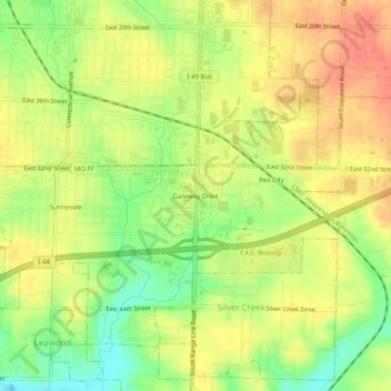
Name: Gateway Drive topographic map, elevation, terrain.
Average elevation: 319 m
Minimum elevation: 290 m
Maximum elevation: 341 m
Thank you for supporting this site ❤️
Make a donation
Make a donation
Other topographic maps
Click on a map to view its topography, its elevation and its terrain.
Shoal Creek
United States > Missouri > Newton County > Joplin > Cliff Village
Average elevation: 295 m