
Thank you for supporting this site ❤️
Make a donation
Make a donation
West Farleigh topographic map
Click on the map to display elevation.
Thank you for supporting this site ❤️
Make a donation
Make a donation
About this map
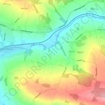
Name: West Farleigh topographic map, elevation, terrain.
Location: West Farleigh, Maidstone, Kent, England, United Kingdom (51.23657 0.41868 51.25909 0.46975)
Average elevation: 60 m
Minimum elevation: 6 m
Maximum elevation: 134 m
Thank you for supporting this site ❤️
Make a donation
Make a donation
Other topographic maps
Click on a map to view its topography, its elevation and its terrain.
Thank you for supporting this site ❤️
Make a donation
Make a donation
Thank you for supporting this site ❤️
Make a donation
Make a donation
Thank you for supporting this site ❤️
Make a donation
Make a donation
Thank you for supporting this site ❤️
Make a donation
Make a donation
The Hernitage and High Noon Farm
United Kingdom > England > Kent > Maidstone > Detling
Average elevation: 145 m
Thank you for supporting this site ❤️
Make a donation
Make a donation