
Thank you for supporting this site ❤️
Make a donation
Make a donation
Stevens Landing topographic map
Click on the map to display elevation.
Thank you for supporting this site ❤️
Make a donation
Make a donation
About this map
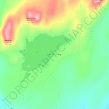
Name: Stevens Landing topographic map, elevation, terrain.
Average elevation: 385 m
Minimum elevation: 303 m
Maximum elevation: 518 m
Thank you for supporting this site ❤️
Make a donation
Make a donation
Other topographic maps
Click on a map to view its topography, its elevation and its terrain.
Au Sable Forks
United States > New York > Clinton County > Town of Black Brook
Average elevation: 238 m