
Thank you for supporting this site ❤️
Make a donation
Make a donation
Coffee Creek topographic map
Click on the map to display elevation.
Thank you for supporting this site ❤️
Make a donation
Make a donation
About this map
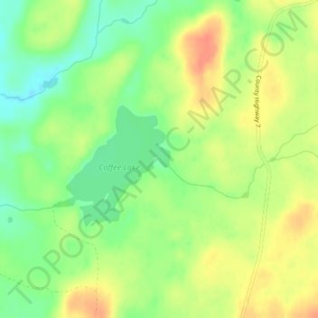
Name: Coffee Creek topographic map, elevation, terrain.
Average elevation: 521 m
Minimum elevation: 497 m
Maximum elevation: 543 m
Thank you for supporting this site ❤️
Make a donation
Make a donation
Other topographic maps
Click on a map to view its topography, its elevation and its terrain.
North Shore Mining/Lake Superior Overlook
United States > Minnesota > Lake County > Silver Bay
Average elevation: 252 m
Thank you for supporting this site ❤️
Make a donation
Make a donation
Thank you for supporting this site ❤️
Make a donation
Make a donation