
Zoutleeuw topographic map
Interactive map
Click on the map to display elevation.
About this map
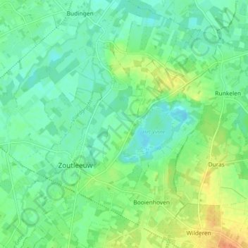
Name: Zoutleeuw topographic map, elevation, terrain.
Location: Zoutleeuw, Leuven, Vlaams-Brabant, Vlaanderen, België (50.81645 5.09023 50.86658 5.14880)
Average elevation: 33 m
Minimum elevation: 20 m
Maximum elevation: 58 m
Other topographic maps
Click on a map to view its topography, its elevation and its terrain.
Budingen
België > Vlaams-Brabant > Leuven > Zoutleeuw
Budingen, Zoutleeuw, Leuven, Vlaams-Brabant, België
Average elevation: 32 m
Dormaal
België > Vlaams-Brabant > Leuven > Zoutleeuw
Dormaal, Zoutleeuw, Leuven, Vlaams-Brabant, Vlaanderen, België
Average elevation: 46 m