
Thank you for supporting this site ❤️
Make a donation
Make a donation
Weed topographic map
Click on the map to display elevation.
Thank you for supporting this site ❤️
Make a donation
Make a donation
About this map
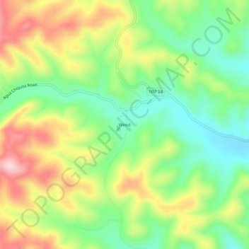
Name: Weed topographic map, elevation, terrain.
Location: Weed, Otero County, New Mexico, 88354, United States (32.78260 -105.53748 32.82260 -105.49748)
Average elevation: 2,212 m
Minimum elevation: 2,106 m
Maximum elevation: 2,356 m
Thank you for supporting this site ❤️
Make a donation
Make a donation
Other topographic maps
Click on a map to view its topography, its elevation and its terrain.
White Sands National Park
United States > New Mexico > Otero County
The first US Army exploration of south-central New Mexico was led by a party of topographical engineering officers in 1849. They passed west of the San Andres Mountains and Organ Mountains. A lieutenant was dispatched east across the basin with a scouting party to map a potential military wagon route to the…
Average elevation: 1,214 m