
Thank you for supporting this site ❤️
Make a donation
Make a donation
Jatikalen topographic map
Click on the map to display elevation.
Thank you for supporting this site ❤️
Make a donation
Make a donation
About this map
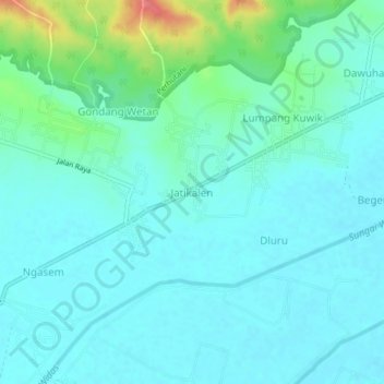
Name: Jatikalen topographic map, elevation, terrain.
Location: Jatikalen, Nganjuk, East Java, Java, 63131, Indonesia (-7.53211 112.09832 -7.49211 112.13832)
Average elevation: 50 m
Minimum elevation: 35 m
Maximum elevation: 111 m
Thank you for supporting this site ❤️
Make a donation
Make a donation
Other topographic maps
Click on a map to view its topography, its elevation and its terrain.
Thank you for supporting this site ❤️
Make a donation
Make a donation