
Thank you for supporting this site ❤️
Make a donation
Make a donation
Thuckalay topographic map
Click on the map to display elevation.
Thank you for supporting this site ❤️
Make a donation
Make a donation
About this map
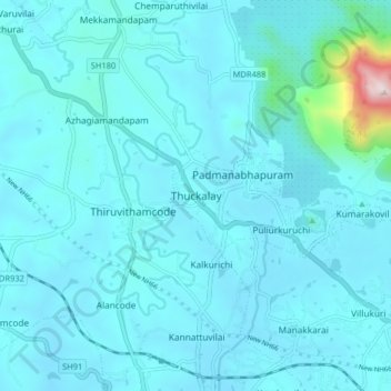
Name: Thuckalay topographic map, elevation, terrain.
Location: Thuckalay, Kalkulam, Kanniyakumari, Tamil Nadu, 629175, India (8.20723 77.27498 8.28723 77.35498)
Average elevation: 84 m
Minimum elevation: 16 m
Maximum elevation: 915 m
Thank you for supporting this site ❤️
Make a donation
Make a donation
Other topographic maps
Click on a map to view its topography, its elevation and its terrain.