
Thank you for supporting this site ❤️
Make a donation
Make a donation
Siler topographic map
Click on the map to display elevation.
Thank you for supporting this site ❤️
Make a donation
Make a donation
About this map
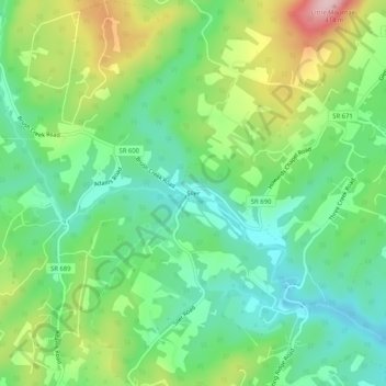
Name: Siler topographic map, elevation, terrain.
Location: Siler, Frederick County, Virginia, United States (39.33066 -78.25889 39.37066 -78.21889)
Average elevation: 257 m
Minimum elevation: 177 m
Maximum elevation: 409 m
Thank you for supporting this site ❤️
Make a donation
Make a donation
Other topographic maps
Click on a map to view its topography, its elevation and its terrain.
Kernstown Battlefield Park
United States > Virginia > Frederick County > Winchester > Valley Acres
Average elevation: 241 m
Thank you for supporting this site ❤️
Make a donation
Make a donation