
Thank you for supporting this site ❤️
Make a donation
Make a donation
Indian Valley topographic map
Click on the map to display elevation.
Thank you for supporting this site ❤️
Make a donation
Make a donation
About this map
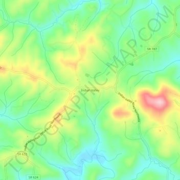
Name: Indian Valley topographic map, elevation, terrain.
Location: Indian Valley, Floyd County, Virginia, 24105, United States (36.88874 -80.57201 36.92874 -80.53201)
Average elevation: 795 m
Minimum elevation: 721 m
Maximum elevation: 921 m
Thank you for supporting this site ❤️
Make a donation
Make a donation
Other topographic maps
Click on a map to view its topography, its elevation and its terrain.
Chestnut Creek Wetlands State Natural Area Preserve
United States > Virginia > Floyd County
Average elevation: 900 m