
Thank you for supporting this site ❤️
Make a donation
Make a donation
Houffalize topographic map
Click on the map to display elevation.
Thank you for supporting this site ❤️
Make a donation
Make a donation
About this map
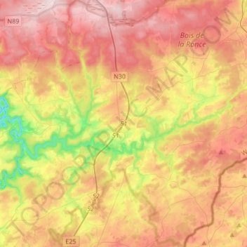
Name: Houffalize topographic map, elevation, terrain.
Location: Houffalize, Bastogne, Luxembourg, Wallonia, Belgium (50.06161 5.65189 50.23613 5.89551)
Average elevation: 463 m
Minimum elevation: 253 m
Maximum elevation: 642 m
Thank you for supporting this site ❤️
Make a donation
Make a donation
Other topographic maps
Click on a map to view its topography, its elevation and its terrain.
Bastogne
Belgium > Luxembourg > Bastogne > Bastogne
The municipality consists of the following districts: Bastogne, Longvilly, Noville, Villers-la-Bonne-Eau, and Wardin. The town is situated on a ridge in the Ardennes at an elevation of 510 metres (1,670 ft).
Average elevation: 505 m
Thank you for supporting this site ❤️
Make a donation
Make a donation
Thank you for supporting this site ❤️
Make a donation
Make a donation
Thank you for supporting this site ❤️
Make a donation
Make a donation