
Thank you for supporting this site ❤️
Make a donation
Make a donation
Rajuri topographic map
Click on the map to display elevation.
Thank you for supporting this site ❤️
Make a donation
Make a donation
About this map
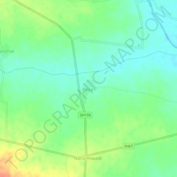
Name: Rajuri topographic map, elevation, terrain.
Location: Rajuri, Osmanabad, Maharashtra, India (18.20819 76.16708 18.24819 76.20708)
Average elevation: 638 m
Minimum elevation: 620 m
Maximum elevation: 669 m
Thank you for supporting this site ❤️
Make a donation
Make a donation
Other topographic maps
Click on a map to view its topography, its elevation and its terrain.