
Thank you for supporting this site ❤️
Make a donation
Make a donation
Columbia Forest topographic map
Click on the map to display elevation.
Thank you for supporting this site ❤️
Make a donation
Make a donation
About this map
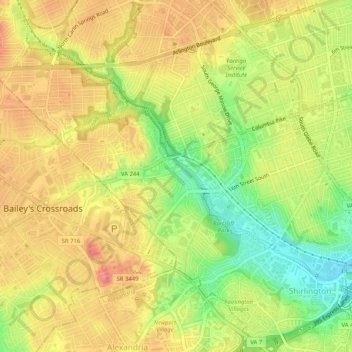
Name: Columbia Forest topographic map, elevation, terrain.
Average elevation: 63 m
Minimum elevation: 11 m
Maximum elevation: 105 m
Thank you for supporting this site ❤️
Make a donation
Make a donation
Other topographic maps
Click on a map to view its topography, its elevation and its terrain.
Thank you for supporting this site ❤️
Make a donation
Make a donation
Fort Meyer Heights Park
United States > Virginia > Arlington County > Arlington
Average elevation: 39 m
Thank you for supporting this site ❤️
Make a donation
Make a donation