
Thank you for supporting this site ❤️
Make a donation
Make a donation
Waterfall topographic map
Click on the map to display elevation.
Thank you for supporting this site ❤️
Make a donation
Make a donation
About this map
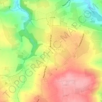
Name: Waterfall topographic map, elevation, terrain.
Average elevation: 96 m
Minimum elevation: 23 m
Maximum elevation: 154 m
Thank you for supporting this site ❤️
Make a donation
Make a donation
Other topographic maps
Click on a map to view its topography, its elevation and its terrain.
Cork
The climate of Cork, like the majority of Ireland, is mild oceanic (Cfb in the Köppen climate classification) and changeable with abundant rainfall and a lack of temperature extremes. Cork lies in plant Hardiness zone 9b. Met Éireann maintains a climatological weather station at Cork Airport, a few…
Average elevation: 79 m
Municipal District of Carrigaline
Ireland > County Cork > Municipal District of Carrigaline
Average elevation: 52 m