
Thank you for supporting this site ❤️
Make a donation
Make a donation
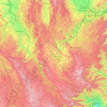
Haute-Loire topographic map
Click on the map to display elevation.
Thank you for supporting this site ❤️
Make a donation
Make a donation
Haute-Loire
The highest point of the department is the Mont Mézenc (1753 m) and its average elevation is 719 m. The two-thirds of the area is over 800 m and the lowest point is 393 m.
Thank you for supporting this site ❤️
Make a donation
Make a donation
About this map
Name: Haute-Loire topographic map, elevation, terrain.
Location: Haute-Loire, Auvergne-Rhône-Alpes, Metropolitan France, France (44.74385 3.08206 45.42763 4.49046)
Average elevation: 895 m
Minimum elevation: 174 m
Maximum elevation: 1,716 m
Thank you for supporting this site ❤️
Make a donation
Make a donation