
Thank you for supporting this site ❤️
Make a donation
Make a donation
Upper Savoy topographic map
Click on the map to display elevation.
Thank you for supporting this site ❤️
Make a donation
Make a donation
About this map
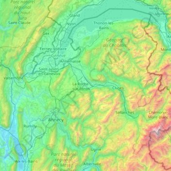
Name: Upper Savoy topographic map, elevation, terrain.
Location: Upper Savoy, Auvergne-Rhône-Alpes, Metropolitan France, France (45.68171 5.80513 46.45637 7.04529)
Average elevation: 1,032 m
Minimum elevation: 225 m
Maximum elevation: 4,728 m
Thank you for supporting this site ❤️
Make a donation
Make a donation
Other topographic maps
Click on a map to view its topography, its elevation and its terrain.
Pointe de Chardonnière
France > Auvergne-Rhône-Alpes > Upper Savoy > Sixt-Fer-à-Cheval
Average elevation: 2,128 m