
Thank you for supporting this site ❤️
Make a donation
Make a donation
Plourac'h topographic map
Click on the map to display elevation.
Thank you for supporting this site ❤️
Make a donation
Make a donation
About this map
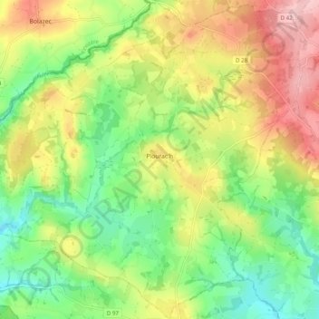
Name: Plourac'h topographic map, elevation, terrain.
Average elevation: 198 m
Minimum elevation: 129 m
Maximum elevation: 287 m
Thank you for supporting this site ❤️
Make a donation
Make a donation
Other topographic maps
Click on a map to view its topography, its elevation and its terrain.
Étang du Moulin
Frankreich > Bretagne > Côtes-d'Armor > Saint-Bihy > Les Roselaies
Average elevation: 234 m
Thank you for supporting this site ❤️
Make a donation
Make a donation
Thank you for supporting this site ❤️
Make a donation
Make a donation
Phare du cap Fréhel
Frankreich > Bretagne > Côtes-d'Armor > Plévenon
Ab dem Jahr 1840 entwarf Léonce Reynaud aufgrund des schlechten Zustands des Gebäudes einen neuen achteckigen Turm mit einer Höhe von 22 Metern und einer Fresnel-Linse. Die Tragweite wurde dadurch auf 25 Seemeilen erhöht. Dieser neue Leuchtturm schlug mit 85.000 Franc zu Buche und konnte am 1. Mai 1847…
Average elevation: 7 m