
Thank you for supporting this site ❤️
Make a donation
Make a donation
Cuyences topographic map
Click on the map to display elevation.
Thank you for supporting this site ❤️
Make a donation
Make a donation
About this map
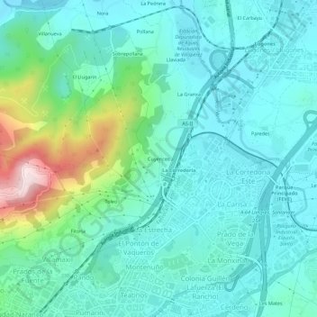
Name: Cuyences topographic map, elevation, terrain.
Location: Cuyences, Oviedo, Asturias, 33011, España (43.36898 -5.85055 43.40898 -5.81055)
Average elevation: 229 m
Minimum elevation: 136 m
Maximum elevation: 595 m
Thank you for supporting this site ❤️
Make a donation
Make a donation
Other topographic maps
Click on a map to view its topography, its elevation and its terrain.
Brañes
El lugar de Brañes se sitúa a una altitud de 200 metros y dista 7,7 km de la ciudad de Oviedo, capital municipal. En el año 2015 tenía una población de 28 habitantes (INE), de poblamiento diseminado, de los que 14 son mujeres y 14 son hombres.. En el año 2000 fue nombrado pueblo ejemplar por el…
Average elevation: 219 m
Thank you for supporting this site ❤️
Make a donation
Make a donation