
Thank you for supporting this site ❤️
Make a donation
Make a donation
Bajan topographic map
Click on the map to display elevation.
Thank you for supporting this site ❤️
Make a donation
Make a donation
About this map
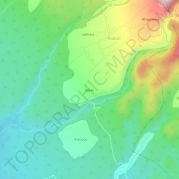
Name: Bajan topographic map, elevation, terrain.
Location: Bajan, Patkot, Ramnagar, Nainital, Uttarakhand, 263159, India (29.41657 79.23413 29.45657 79.27413)
Average elevation: 694 m
Minimum elevation: 552 m
Maximum elevation: 1,014 m
Thank you for supporting this site ❤️
Make a donation
Make a donation