
Make a donation
Wayne County topographic map
Click on the map to display elevation.
Make a donation
Wayne County
Grosse Ile is the largest island in the county and is connected to the mainland by the Wayne County Bridge and the Grosse Ile Toll Bridge. The highest elevation (990 feet (300 m)) in the county is near Northville, in Maybury State Park.
Make a donation
About this map
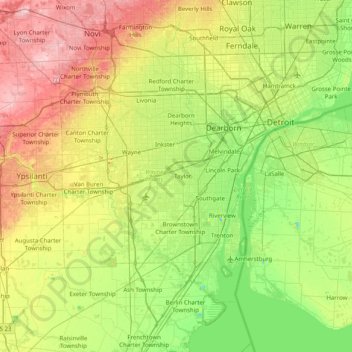
Name: Wayne County topographic map, elevation, terrain.
Location: Wayne County, Michigan, United States (42.02793 -83.55189 42.45141 -82.75029)
Average elevation: 203 m
Minimum elevation: 138 m
Maximum elevation: 323 m
Make a donation
Other topographic maps
Click on a map to view its topography, its elevation and its terrain.
Dean Lake
United States > Michigan > Kent County > Plainfield Charter Township
Average elevation: 228 m
Muskegon River - South Channel
United States > Michigan > Muskegon County > Muskegon
Average elevation: 188 m
Make a donation
Make a donation
Grand Island
United States > Michigan > Presque Isle County > Presque Isle Township
Average elevation: 182 m
Make a donation
Make a donation
Make a donation
Make a donation
Oakley Park
United States > Michigan > Oakland County > Commerce Charter Township
Average elevation: 282 m
Make a donation
Make a donation
Make a donation
North Branch Marsh Drain
United States > Michigan > Washtenaw County > Augusta Township
Average elevation: 206 m
Make a donation
Make a donation
Make a donation
South Gull Lake
United States > Michigan > Kalamazoo County > South Gull Lake
Average elevation: 274 m
Make a donation
Make a donation
Make a donation