
Thank you for supporting this site ❤️
Make a donation
Make a donation
Yucca Valley topographic map
Click on the map to display elevation.
Thank you for supporting this site ❤️
Make a donation
Make a donation
Yucca Valley
Yucca Valley lies in the middle of the Morongo Basin at a base elevation of 3,300 feet. Joshua Tree National Park is adjacent to its southern border.
Thank you for supporting this site ❤️
Make a donation
Make a donation
About this map
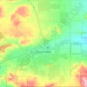
Name: Yucca Valley topographic map, elevation, terrain.
Average elevation: 1,106 m
Minimum elevation: 897 m
Maximum elevation: 1,501 m
Thank you for supporting this site ❤️
Make a donation
Make a donation
Other topographic maps
Click on a map to view its topography, its elevation and its terrain.