
Thank you for supporting this site ❤️
Make a donation
Make a donation
Reeds Spring topographic map
Click on the map to display elevation.
Thank you for supporting this site ❤️
Make a donation
Make a donation
About this map
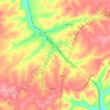
Name: Reeds Spring topographic map, elevation, terrain.
Location: Reeds Spring, Stone County, Missouri, United States (36.72668 -93.39493 36.76667 -93.34877)
Average elevation: 399 m
Minimum elevation: 322 m
Maximum elevation: 436 m
Thank you for supporting this site ❤️
Make a donation
Make a donation
Other topographic maps
Click on a map to view its topography, its elevation and its terrain.