
Thank you for supporting this site ❤️
Make a donation
Make a donation
Cisco topographic map
Click on the map to display elevation.
Thank you for supporting this site ❤️
Make a donation
Make a donation
About this map
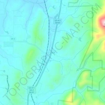
Name: Cisco topographic map, elevation, terrain.
Location: Cisco, Murray County, Georgia, 30708, United States (34.93119 -84.75633 34.97119 -84.71633)
Average elevation: 293 m
Minimum elevation: 236 m
Maximum elevation: 565 m
Thank you for supporting this site ❤️
Make a donation
Make a donation
Other topographic maps
Click on a map to view its topography, its elevation and its terrain.