
Thank you for supporting this site ❤️
Make a donation
Make a donation
Wayne Township topographic map
Click on the map to display elevation.
Thank you for supporting this site ❤️
Make a donation
Make a donation
About this map
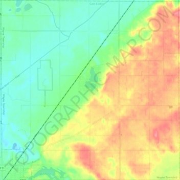
Name: Wayne Township topographic map, elevation, terrain.
Location: Wayne Township, Cass County, Michigan, United States (41.98363 -86.10778 42.07074 -85.99121)
Average elevation: 251 m
Minimum elevation: 218 m
Maximum elevation: 295 m
Thank you for supporting this site ❤️
Make a donation
Make a donation
Other topographic maps
Click on a map to view its topography, its elevation and its terrain.
Thank you for supporting this site ❤️
Make a donation
Make a donation
Thank you for supporting this site ❤️
Make a donation
Make a donation