
Thank you for supporting this site ❤️
Make a donation
Make a donation
Girirejo topographic map
Click on the map to display elevation.
Thank you for supporting this site ❤️
Make a donation
Make a donation
About this map
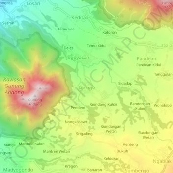
Name: Girirejo topographic map, elevation, terrain.
Location: Girirejo, Magelang, Central Java, Java, 56194, Indonesia (-7.40662 110.36366 -7.36662 110.40366)
Average elevation: 1,264 m
Minimum elevation: 904 m
Maximum elevation: 1,715 m
Thank you for supporting this site ❤️
Make a donation
Make a donation
Other topographic maps
Click on a map to view its topography, its elevation and its terrain.
Thank you for supporting this site ❤️
Make a donation
Make a donation
Thank you for supporting this site ❤️
Make a donation
Make a donation