
Make a donation
Hoene Spring topographic map
Click on the map to display elevation.
Make a donation
About this map
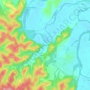
Name: Hoene Spring topographic map, elevation, terrain.
Average elevation: 165 m
Minimum elevation: 128 m
Maximum elevation: 250 m
Make a donation
Other topographic maps
Click on a map to view its topography, its elevation and its terrain.
Pacific Palisades Conservation Area
United States > Missouri > Jefferson County
Average elevation: 152 m
Make a donation
Big River
United States > Missouri > Jefferson County > Cedar Hill
The Big River is a tributary of the Meramec River in east-central Missouri. The river rises in western Iron County near the summit of Johnson Mountain just north of Missouri Route 32 and approximately 3.5 miles southeast of the community of Enough. It flows through Washington, Saint Francois, and Jefferson…
Average elevation: 220 m
Make a donation
Make a donation
Myron and Sonya Glassberg Conservation Area
United States > Missouri > Jefferson County
Average elevation: 171 m