
Make a donation
Ile-de-France topographic map
Click on the map to display elevation.
Make a donation
Ile-de-France
The River Seine flows through the middle of the region, which is crisscrossed by its tributaries and sub-tributaries, including the Rivers Marne, Oise and Epte. The River Eure does not cross the region but receives water from several rivers in the Île-de-France, including the Drouette and the Vesgre. The major rivers are navigable, and, because of the modest variations of altitude in the region (between 10 metres (33 ft) and 200 metres (660 ft)), they have a tendency to meander and curve. They also create many lakes and ponds, some of which have been transformed into recreation areas, including Moisson-Mousseaux, Cergy-Neuville and Villeneuve-Saint-Georges.
Make a donation
About this map
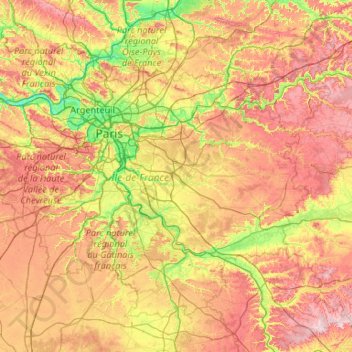
Name: Ile-de-France topographic map, elevation, terrain.
Location: Ile-de-France, Metropolitan France, France (48.12015 1.44624 49.24143 3.55922)
Average elevation: 124 m
Minimum elevation: 17 m
Maximum elevation: 304 m
Make a donation
Other topographic maps
Click on a map to view its topography, its elevation and its terrain.
Make a donation
Les Eschartès
France > Nouvelle-Aquitaine > Pyrénées-Atlantiques > Louvie-Soubiron
Average elevation: 942 m
Cime de la Bonette
France > Provence-Alpes-Côte d'Azur > Maritime Alps > Saint-Dalmas-le-Selvage
Average elevation: 2,512 m
Make a donation
La Villa Trévi
France > Auvergne-Rhône-Alpes > Upper Savoy > Épagny Metz-Tessy
Average elevation: 493 m
Aurafrède
France > Provence-Alpes-Côte d'Azur > Alpes-de-Haute-Provence > Gréoux-les-Bains
Average elevation: 389 m
Make a donation
Champ
France > Auvergne-Rhône-Alpes > Ardèche > Saint-Romain-de-Lerps > Roussiveyrent
Average elevation: 501 m
Make a donation
Valence
France > Auvergne-Rhône-Alpes > Drôme
The area of the commune is 3,669 hectares (9,070 acres), representing 36.69 square kilometres (14.17 sq mi); the altitude varies between 106–191 metres (348–627 ft).
Average elevation: 287 m
Make a donation
Fatu Huku
France > French Polynesia > Marquesas Islands > Hiva Oa
The island is essentially a huge rock, looming steep-sided out of the ocean and rising to a flattened plateau with a maximum elevation of 361 metres (1,184 ft). Fatu Huku is the youngest of the volcanic Marquesas Islands, estimated to be only 1.3 million years old which accounts, in part, for its ruggedness as…
Average elevation: 8 m
Make a donation
Agusan
France > New Aquitaine > Lot-et-Garonne > Laplume > Laplatrière de Bordeneuve
Average elevation: 159 m
Make a donation