
Thank you for supporting this site ❤️
Make a donation
Make a donation
Addison (Webster Springs) topographic map
Click on the map to display elevation.
Thank you for supporting this site ❤️
Make a donation
Make a donation
Addison (Webster Springs)
Webster Springs is located at 38°28′34″N 80°24′36″W / 38.47611°N 80.41000°W / 38.47611; -80.41000 (38.476192, -80.410025), along the Elk River. According to the United States Census Bureau, the town has a total area of 0.47 square miles (1.22 km2), of which 0.45 square miles (1.17 km2) is land and 0.02 square miles (0.05 km2) is water. It lies at an elevation of 1,460 ft. (445m) and is close to Buffalo Bull Knob, elevation 2,799 ft.
Thank you for supporting this site ❤️
Make a donation
Make a donation
About this map
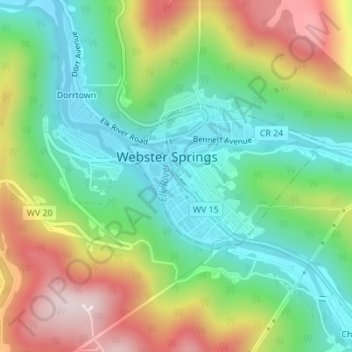
Name: Addison (Webster Springs) topographic map, elevation, terrain.
Average elevation: 602 m
Minimum elevation: 431 m
Maximum elevation: 878 m
Thank you for supporting this site ❤️
Make a donation
Make a donation
Other topographic maps
Click on a map to view its topography, its elevation and its terrain.