
Thank you for supporting this site ❤️
Make a donation
Make a donation
Orford topographic map
Click on the map to display elevation.
Thank you for supporting this site ❤️
Make a donation
Make a donation
About this map
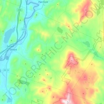
Name: Orford topographic map, elevation, terrain.
Location: Orford, Grafton County, New Hampshire, United States (43.83795 -72.17370 43.95761 -71.96389)
Average elevation: 300 m
Minimum elevation: 111 m
Maximum elevation: 979 m
Thank you for supporting this site ❤️
Make a donation
Make a donation
Other topographic maps
Click on a map to view its topography, its elevation and its terrain.