
Thank you for supporting this site ❤️
Make a donation
Make a donation
Valdoviño topographic map
Click on the map to display elevation.
Thank you for supporting this site ❤️
Make a donation
Make a donation
About this map
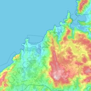
Name: Valdoviño topographic map, elevation, terrain.
Location: Valdoviño, Ferrol, A Coruña, Galicia, Spain (43.54878 -8.22378 43.66981 -8.01913)
Average elevation: 84 m
Minimum elevation: -5 m
Maximum elevation: 357 m
Thank you for supporting this site ❤️
Make a donation
Make a donation
Other topographic maps
Click on a map to view its topography, its elevation and its terrain.