Geolocate

Jokkmokk topographic map

Click on the map to display elevation.

Jokkmokk

Influenced by its inland and northerly position, Jokkmokk's variety of a subarctic climate (Dfc) is very cold by Swedish standards. Summers are normally relatively mild, with midnight sun, and the dark winters are long and cold, although polar night is not quite observed with a sun angle of 0.4° at the winter solstice. Combining an elevation of 250 metres (820 ft) with being at the foot of the Scandinavian Mountains, Jokkmokk is both cooled down during the day and experiences temperature inversion during night. This combination makes it the coldest municipal seat in Sweden in terms of winter temperatures, although some rural localities in Lapland are even colder.

Wikipedia (CC-BY-SA 3.0)

About this map

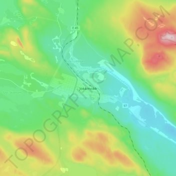
Name: Jokkmokk topographic map, elevation, terrain.

Location: Jokkmokk, Jokkmokks kommun, Norrbotten County, 962 85, Sweden (66.56585 19.79793 66.64585 19.87793)

Average elevation: 293 m

Minimum elevation: 204 m

Maximum elevation: 498 m

Other topographic maps

Click on a map to view its topography, its elevation and its terrain.

Gällivare kommun

Sweden > Norrbotten County

Average elevation: 486 m

Gällivare kommun

Sweden > Norrbotten County

Average elevation: 486 m

Abisko National Park

Sweden > Norrbotten County

Permafrost is common in the national park, though permafrost at lower elevations is disappearing because of global warming and increased snowfall.

Average elevation: 740 m

Arjeplogs kommun

Sweden > Norrbotten County

Average elevation: 680 m

Kebnekaise

Sweden > Norrbotten County

Average elevation: 1,307 m

Gällivare kommun

Sweden > Norrbotten County

Average elevation: 486 m

Kiruna kommun

Sweden > Norrbotten County

Average elevation: 618 m

Kebnekaise

Sweden > Norrbotten County

Average elevation: 1,658 m

Kebnekaise

Sweden > Norrbotten County

Average elevation: 1,307 m

Kebnekaise

Sweden > Norrbotten County

Average elevation: 1,307 m

Kebnekaise

Sweden > Norrbotten County

Average elevation: 1,307 m

Kebnekaise

Sweden > Norrbotten County

Average elevation: 1,307 m

Jokkmokks kommun

Sweden > Norrbotten County

Average elevation: 538 m

Stora Brändön

Sweden > Norrbotten County

Average elevation: 4 m

Riebnes

Sweden > Norrbotten County

Average elevation: 637 m

Arvidsjaurs kommun

Sweden > Norrbotten County

Average elevation: 388 m

Torneträsk

Sweden > Norrbotten County

Permafrost is common in the land around the lake. This low elevation permafrost is disappearing because of global warming and increased snowfall.

Average elevation: 768 m

Luleå kommun

Sweden > Norrbotten County

Average elevation: 63 m

Haparanda kommun

Sweden > Norrbotten County

Average elevation: 0 m

Jukkasjärvi

Sweden > Norrbotten County

Average elevation: 395 m

Pajala kommun

Sweden > Norrbotten County

Average elevation: 262 m

Kalix kommun

Sweden > Norrbotten County

Average elevation: 33 m

Kebnekaise

Sweden > Norrbotten County

Average elevation: 1,656 m

Piteå kommun

Sweden > Norrbotten County

Average elevation: 88 m

Kiruna kommun

Sweden > Norrbotten County

Average elevation: 620 m

Älvsbyns kommun

Sweden > Norrbotten County

Average elevation: 154 m

Kiruna kommun

Sweden > Norrbotten County

Average elevation: 618 m

Vargön

Sweden > Norrbotten County

Average elevation: 3 m

Kiruna kommun

Sweden > Norrbotten County

Average elevation: 618 m

Luleå Stadspark

Sweden > Norrbotten County > Luleå

Average elevation: 3 m

Latnjajávri

Sweden > Norrbotten County

Average elevation: 1,153 m

Parki

Sweden > Norrbotten County > Parkijaur

Average elevation: 294 m