
Make a donation
Tabir Ilir topographic map
Click on the map to display elevation.
Make a donation
About this map
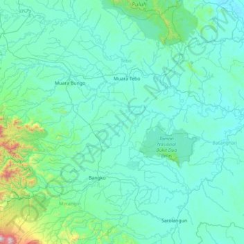
Name: Tabir Ilir topographic map, elevation, terrain.
Location: Tabir Ilir, Jambi, Sumatra, 37368, Indonesia (-2.44343 101.71839 -1.04343 103.11839)
Average elevation: 151 m
Minimum elevation: 2 m
Maximum elevation: 2,442 m
Make a donation
Other topographic maps
Click on a map to view its topography, its elevation and its terrain.
Make a donation
Make a donation
Taman Anggrek Sri Sudewi
Indonesia > Jambi > Danau Sipin > Jambi > Telanaipura
Average elevation: 21 m
Make a donation
Sungai Bungkal
Indonesia > Jambi > Hamparan Rawang > Sungai Penuh > Pasar Sungai Penuh
Average elevation: 820 m
Make a donation
Make a donation
Make a donation
Jambi
The total land area of Jambi city is 205.38 km2 (79 sq mi). Jambi City is located at the south-western portion of the Sumatran Basin, a low-lying area in Eastern Sumatra with an altitude of 0 to 60m above sea level. A segment of the Batanghari River, the longest river in Sumatra at 1,700 km (1,056 mi), flows…
Average elevation: 22 m
Make a donation
Make a donation
Make a donation