
Thank you for supporting this site ❤️
Make a donation
Make a donation
Raja Basa topographic map
Click on the map to display elevation.
Thank you for supporting this site ❤️
Make a donation
Make a donation
About this map
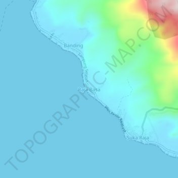
Name: Raja Basa topographic map, elevation, terrain.
Location: Raja Basa, Lampung Selatan, Lampung, Sumatra, Indonesia (-5.83961 105.57655 -5.79961 105.61655)
Average elevation: 51 m
Minimum elevation: 0 m
Maximum elevation: 462 m
Thank you for supporting this site ❤️
Make a donation
Make a donation
Other topographic maps
Click on a map to view its topography, its elevation and its terrain.