
Make a donation
Kralendijk topographic map
Click on the map to display elevation.
Make a donation
About this map
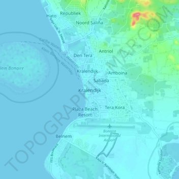
Name: Kralendijk topographic map, elevation, terrain.
Location: Kralendijk, Bonaire, Netherlands, 0000 BQ, Netherlands (12.10729 -68.31402 12.18729 -68.23402)
Average elevation: 9 m
Minimum elevation: -2 m
Maximum elevation: 114 m
Make a donation
Other topographic maps
Click on a map to view its topography, its elevation and its terrain.
Amsterdam
Amsterdam is located in the Western Netherlands, in the province of North Holland, the capital of which is not Amsterdam, but rather Haarlem. The river Amstel ends in the city centre and connects to a large number of canals that eventually terminate in the IJ. Amsterdam's elevation is about −2 m (−6.6 ft)…
Average elevation: 0 m
Make a donation
Eindhoven
The villages and city that make up modern Eindhoven were originally built on sandy elevations between the Dommel, Gender and Tongelreep rivers. Beginning in the 19th century, the basins of the rivers themselves have also been used as housing land, resulting in occasional flooding in the city centre. Partly to…
Average elevation: 20 m
Make a donation
Make a donation
Bonaire
While Bonaire has some hills and variations in altitude, Klein Bonaire's surface is quite level and just about two meters above sea level. Because Klein Bonaire is as yet undeveloped, the fringing reef system surrounding Klein Bonaire is pristine.
Average elevation: 1 m
Make a donation
Make a donation
Make a donation
Make a donation
Bonaire
Klein Bonaire, the small island in the sheltered lee of Bonaire, has the same geological history. While Bonaire has some hills and variations in altitude, Klein Bonaire's surface is quite level and just a few feet above high tide. Because the island is as yet undeveloped, the fringing reef system surrounding…
Average elevation: 1 m
Make a donation
Bonaire
While Bonaire has some hills and variations in altitude, Klein Bonaire's surface is quite level and just about two meters above sea level. Because Klein Bonaire is as yet undeveloped, the fringing reef system surrounding Klein Bonaire is pristine.
Average elevation: 1 m
Make a donation
Bonaire
Klein Bonaire, the small island in the sheltered lee of Bonaire, has the same geological history. While Bonaire has some hills and variations in altitude, Klein Bonaire's surface is quite level and just a few feet above high tide. Because the island is as yet undeveloped, the fringing reef system surrounding…
Average elevation: 6 m
Make a donation
Saba
There is an 8.6 hectares (21 acres) cloud forest located at and above 825 metres (2,707 ft) on top of the mountain referred to as the "Elfin Forest Reserve" because of its high altitude mist and mossy appearance. The most dominant tree in the cloud forest is the Mountain Mahogany (Freziera undulate), although…
Average elevation: 2 m
Make a donation
Make a donation
Make a donation
Walcheren
Topographic map of Walcheren, 2015-2016. Click to enlarge.
Average elevation: 0 m
Make a donation
Breda
Topographic map image of the city of Breda, March 2014. Click to enlarge.
Average elevation: 7 m
Make a donation
Apeldoorn
In 1689 William III became King of England, Scotland and Ireland and this elevation of his position and power brought an enlargement of Het Loo in its wake. Between 1691 and 1694 the colonnades which linked the corps de logis to the wings on either side were replaced by four pavilions. These pavilions…
Average elevation: 26 m
Sint Eustatius
Sint Eustatius is 6 miles (10 km) long and up to 3 miles (5 km) wide. Topographically, the island is saddle-shaped, with the 602-metre (1,975 ft) high dormant volcano Quill (Mount Mazinga), (from Dutch kuil, meaning 'pit'—originally referring to its crater) to the southeast and the smaller summits of Signal…
Average elevation: 12 m
Make a donation
Make a donation
Make a donation
Wageningen
Netherlands > Gelderland > Wageningen
Topographic map of the municipality of Wageningen, July 2013 (click to enlarge)
Average elevation: 14 m
Make a donation
Amsterdam
Amsterdam is located in the Western Netherlands, in the province of North Holland, the capital of which is not Amsterdam, but rather Haarlem. The river Amstel ends in the city centre and connects to a large number of canals that eventually terminate in the IJ. Amsterdam's elevation is about −2 m (−6.6 ft)…
Average elevation: 0 m
Duiven
Dutch Topographic map of the municipality of Duiven, June 2015
Average elevation: 11 m
Make a donation
Make a donation
Apeldoorn
In 1689 William III became King of England, Scotland and Ireland and this elevation of his position and power brought an enlargement of Het Loo in its wake. Between 1691 and 1694 the colonnades which linked the corps de logis to the wings on either side were replaced by four pavilions. These pavilions…
Average elevation: 36 m
Make a donation
Make a donation
Amsterdam
Amsterdam is located in the Western Netherlands, in the province of North Holland, the capital of which is not Amsterdam, but rather Haarlem. The river Amstel ends in the city centre and connects to a large number of canals that eventually terminate in the IJ. Amsterdam's elevation is about −2 m (−6.6 ft)…
Average elevation: 0 m
Amersfoort
The construction of the tower and the church was started in 1444. The church was destroyed by an explosion in 1787, but the tower survived, and the layout of the church still can be discerned today through the use of different types of stone in the pavement of the open space that was created. It is now the…
Average elevation: 7 m
Make a donation