
Thank you for supporting this site ❤️
Make a donation
Make a donation
Cortes topographic map
Click on the map to display elevation.
Thank you for supporting this site ❤️
Make a donation
Make a donation
About this map
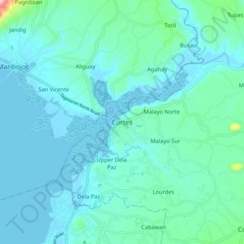
Name: Cortes topographic map, elevation, terrain.
Location: Cortes, Bohol, Central Visayas, 6330, Philippines (9.68248 123.83918 9.76248 123.91918)
Average elevation: 31 m
Minimum elevation: -4 m
Maximum elevation: 262 m
Thank you for supporting this site ❤️
Make a donation
Make a donation
Other topographic maps
Click on a map to view its topography, its elevation and its terrain.