Cheshire topographic map
Interactive map
Click on the map to display elevation.
About this map
![Cheshire topographic map, elevation, terrain](/pub/maps/relation/f4zs/k54b3/thumbnail.jpg)
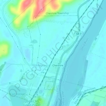
Name: Cheshire topographic map, elevation, terrain.
Location: Cheshire, Gallia County, Ohio, United States (38.93873 -82.12164 38.95778 -82.10450)
Average elevation: 180 m
Minimum elevation: 166 m
Maximum elevation: 263 m
Other topographic maps
Click on a map to view its topography, its elevation and its terrain.
![Gallia County Fairgrounds topographic map, elevation, terrain](/pub/maps/node/6n4s/tr27k57/icon.jpg)
Gallia County Fairgrounds
United States > Ohio > Gallia County
Gallia County Fairgrounds, Springfield Township, Gallia County, Ohio, 45631, United States
Average elevation: 200 m
![Rio Grande topographic map, elevation, terrain](/pub/maps/relation/lhb3/vmgtj/icon.jpg)
Rio Grande
United States > Ohio > Gallia County
Rio Grande, Gallia County, Ohio, United States
Average elevation: 209 m
![Evergreen topographic map, elevation, terrain](/pub/maps/node/wxf3/wcsfxtf/icon.jpg)
Evergreen
United States > Ohio > Gallia County
Evergreen, Springfield Township, Gallia County, Ohio, 45614, United States
Average elevation: 219 m
![Northup topographic map, elevation, terrain](/pub/maps/node/wsnx/9q88wzs/icon.jpg)
Northup
United States > Ohio > Gallia County
Northup, Green Township, Gallia County, Ohio, United States
Average elevation: 204 m
![Centerville topographic map, elevation, terrain](/pub/maps/relation/41gp/zn7nx/icon.jpg)
Centerville
United States > Ohio > Gallia County
Centerville, Gallia County, Ohio, United States
Average elevation: 221 m
![Harrisburg topographic map, elevation, terrain](/pub/maps/node/q2nx/xz2l8kl/icon.jpg)
Harrisburg
United States > Ohio > Gallia County
Harrisburg, Raccoon Township, Gallia County, Ohio, 45674, United States
Average elevation: 205 m
![Bidwell topographic map, elevation, terrain](/pub/maps/node/m751/75nc918/icon.jpg)
Bidwell
United States > Ohio > Gallia County
Bidwell, Springfield Township, Gallia County, Ohio, 45614, United States
Average elevation: 216 m
![Mercerville topographic map, elevation, terrain](/pub/maps/node/hwdn/lxq58gp/icon.jpg)
Mercerville
United States > Ohio > Gallia County
Mercerville, Guyan Township, Gallia County, Ohio, 45623, United States
Average elevation: 245 m
![Porter topographic map, elevation, terrain](/pub/maps/node/7c9m/zt637nx/icon.jpg)
Porter
United States > Ohio > Gallia County
Porter, Springfield Township, Gallia County, Ohio, 45614, United States
Average elevation: 222 m
![Adamsville topographic map, elevation, terrain](/pub/maps/node/4lgt/dg53mz4/icon.jpg)
Adamsville
United States > Ohio > Gallia County
Adamsville, Raccoon Township, Gallia County, Ohio, 45674, United States
Average elevation: 203 m
![Ewington topographic map, elevation, terrain](/pub/maps/node/3718/4dk4wm2/icon.jpg)
Ewington
United States > Ohio > Gallia County
Ewington, Huntington Township, Gallia County, Ohio, 45686, United States
Average elevation: 210 m
![Gallia topographic map, elevation, terrain](/pub/maps/node/s7nh/7jfwj18/icon.jpg)
Gallia
United States > Ohio > Gallia County
Gallia, Greenfield Township, Gallia County, Ohio, United States
Average elevation: 224 m
![Rodney topographic map, elevation, terrain](/pub/maps/node/7gp/jv88h5k/icon.jpg)
Rodney
United States > Ohio > Gallia County
Rodney, Green Township, Gallia County, Ohio, United States
Average elevation: 215 m
![Kanauga topographic map, elevation, terrain](/pub/maps/node/k2tf/xzpwnkl/icon.jpg)
Kanauga
United States > Ohio > Gallia County
Kanauga, Gallipolis Township, Gallia County, Ohio, 25106, United States
Average elevation: 187 m
![Centerpoint topographic map, elevation, terrain](/pub/maps/node/ffgp/dgprh14/icon.jpg)
Centerpoint
United States > Ohio > Gallia County
Centerpoint, Perry Township, Gallia County, Ohio, United States
Average elevation: 235 m
![Kerr topographic map, elevation, terrain](/pub/maps/node/k51/xzckrkl/icon.jpg)
Kerr
United States > Ohio > Gallia County
Kerr, Springfield Township, Gallia County, Ohio, 45614, United States
Average elevation: 205 m
![Springfield Township topographic map, elevation, terrain](/pub/maps/relation/5c3l/zk93kl/icon.jpg)
Springfield Township
United States > Ohio > Gallia County
Springfield Township, Gallia County, Ohio, 45614, United States
Average elevation: 215 m
![Vinton topographic map, elevation, terrain](/pub/maps/relation/prdn/4fzm2/icon.jpg)
Vinton
United States > Ohio > Gallia County
Vinton, Gallia County, Ohio, 45686, United States
Average elevation: 207 m
![Patriot topographic map, elevation, terrain](/pub/maps/node/9jkl/b238st6/icon.jpg)
Patriot
United States > Ohio > Gallia County
Patriot, Perry Township, Gallia County, Ohio, 45658, United States
Average elevation: 225 m
![Gallipolis topographic map, elevation, terrain](/pub/maps/relation/g6nx/6gp9m/icon.jpg)
Gallipolis
United States > Ohio > Gallia County
Gallipolis, Gallia County, Ohio, United States
Average elevation: 203 m
![Crown City topographic map, elevation, terrain](/pub/maps/relation/cg3q/372dn/icon.jpg)
Crown City
United States > Ohio > Gallia County
Crown City, Gallia County, Ohio, United States
Average elevation: 202 m
![Bulaville topographic map, elevation, terrain](/pub/maps/node/4t1h/3kwsddn/icon.jpg)
Bulaville
United States > Ohio > Gallia County
Bulaville, Addison Township, Gallia County, Ohio, United States
Average elevation: 206 m
![Kyger topographic map, elevation, terrain](/pub/maps/node/sxtp/wcl38tf/icon.jpg)
Kyger
United States > Ohio > Gallia County
Kyger, Cheshire Township, Gallia County, Ohio, 45620, United States
Average elevation: 220 m