
Villecroze-les-Grottes topographic map
Interactive map
Click on the map to display elevation.
About this map
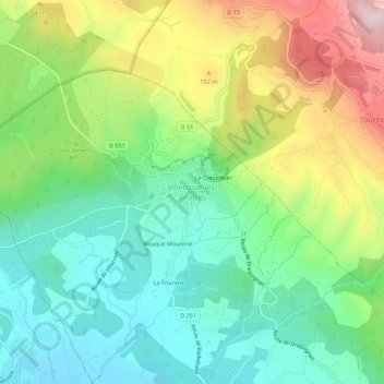
Name: Villecroze-les-Grottes topographic map, elevation, terrain.
Average elevation: 414 m
Minimum elevation: 237 m
Maximum elevation: 738 m
Other topographic maps
Click on a map to view its topography, its elevation and its terrain.
Le Colombier
France > Provence-Alpes-Côte d'Azur > Var > Villecroze > Villecroze-les-Grottes
Le Colombier, Villecroze-les-Grottes, Villecroze, Brignoles, Var, Provence-Alpes-Côte d'Azur, France métropolitaine, 83690, France
Average elevation: 435 m
La Bourie-Est
France > Provence-Alpes-Côte d'Azur > Var > Villecroze > Villecroze-les-Grottes
La Bourie-Est, Villecroze-les-Grottes, Villecroze, Brignoles, Var, Provence-Alpes-Côte d'Azur, France métropolitaine, 83690, France
Average elevation: 406 m
La Bourie-Ouest
France > Provence-Alpes-Côte d'Azur > Var > Villecroze > Villecroze-les-Grottes
La Bourie-Ouest, Villecroze-les-Grottes, Villecroze, Brignoles, Var, Provence-Alpes-Côte d'Azur, France métropolitaine, 83690, France
Average elevation: 388 m