
Thank you for supporting this site ❤️
Make a donation
Make a donation
Fisher Hills topographic map
Click on the map to display elevation.
Thank you for supporting this site ❤️
Make a donation
Make a donation
About this map
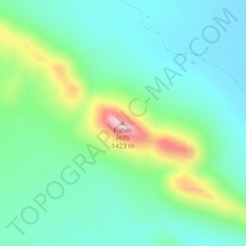
Name: Fisher Hills topographic map, elevation, terrain.
Location: Fisher Hills, Cochise County, Arizona, United States (32.39225 -109.58178 32.39235 -109.58168)
Average elevation: 1,237 m
Minimum elevation: 1,158 m
Maximum elevation: 1,463 m
Thank you for supporting this site ❤️
Make a donation
Make a donation
Other topographic maps
Click on a map to view its topography, its elevation and its terrain.
Thank you for supporting this site ❤️
Make a donation
Make a donation
Kartchner Caverns State Park
United States > Arizona > Cochise County > Benson
Average elevation: 1,432 m