Geolocate

Plan Redon topographic map

Interactive map

Click on the map to display elevation.

About this map

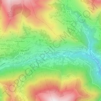
Name: Plan Redon topographic map, elevation, terrain.

Location: Plan Redon, Castillon-de-Larboust, Saint-Gaudens, Haute-Garonne, Occitanie, France métropolitaine, 31110, France (42.78619 0.51921 42.82619 0.55921)

Average elevation: 1,196 m

Minimum elevation: 749 m

Maximum elevation: 1,759 m

Other topographic maps

Click on a map to view its topography, its elevation and its terrain.

Vallée du Lys

France > Occitanie > Haute-Garonne > Castillon-de-Larboust

Vallée du Lys, Castillon-de-Larboust, Saint-Gaudens, Haute-Garonne, Occitanie, France métropolitaine, 31110, France

Average elevation: 1,436 m

Cascade d'Enfer

France > Occitanie > Haute-Garonne > Castillon-de-Larboust

Cascade d'Enfer, Castillon-de-Larboust, Saint-Gaudens, Haute-Garonne, Occitanie, France métropolitaine, 31110, France

Average elevation: 1,640 m

Refuge du Maupas

France > Occitanie > Haute-Garonne > Castillon-de-Larboust

Refuge du Maupas, D46a, Castillon-de-Larboust, Saint-Gaudens, Haute-Garonne, Occitanie, France métropolitaine, 31110, France

Average elevation: 2,241 m

Lasvignes

France > Occitanie > Haute-Garonne > Castillon-de-Larboust

Lasvignes, Castillon-de-Larboust, Saint-Gaudens, Haute-Garonne, Occitanie, France métropolitaine, 31110, France

Average elevation: 1,194 m