
Thank you for supporting this site ❤️
Make a donation
Make a donation
Ostuni topographic map
Click on the map to display elevation.
Thank you for supporting this site ❤️
Make a donation
Make a donation
About this map
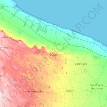
Name: Ostuni topographic map, elevation, terrain.
Location: Ostuni, Brindisi, Apulia, 72017, Italy (40.64153 17.36467 40.81790 17.67662)
Average elevation: 132 m
Minimum elevation: -3 m
Maximum elevation: 397 m
Thank you for supporting this site ❤️
Make a donation
Make a donation
Other topographic maps
Click on a map to view its topography, its elevation and its terrain.