
Thank you for supporting this site ❤️
Make a donation
Make a donation
Trujillo topographic map
Click on the map to display elevation.
Thank you for supporting this site ❤️
Make a donation
Make a donation
About this map
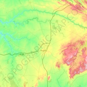
Name: Trujillo topographic map, elevation, terrain.
Location: Trujillo, Cáceres, Extremadura, 10200, Spain (39.32240 -6.30515 39.66723 -5.73075)
Average elevation: 475 m
Minimum elevation: 241 m
Maximum elevation: 1,013 m
Thank you for supporting this site ❤️
Make a donation
Make a donation
Other topographic maps
Click on a map to view its topography, its elevation and its terrain.
Madrigal de la Vera
Spain > Extremadura > La Vera > Madrigal de la Vera > Madrigal de la Vera
Average elevation: 400 m
Thank you for supporting this site ❤️
Make a donation
Make a donation