
Nunkirchen topographic map
Interactive map
Click on the map to display elevation.
About this map
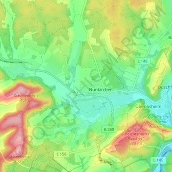
Name: Nunkirchen topographic map, elevation, terrain.
Average elevation: 297 m
Minimum elevation: 232 m
Maximum elevation: 402 m
Other topographic maps
Click on a map to view its topography, its elevation and its terrain.
Münchweiler
Deutschland > Saarland > Landkreis Merzig-Wadern > Wadern
Münchweiler, Nunkirchen, Wadern, Landkreis Merzig-Wadern, Saarland, Deutschland
Average elevation: 293 m
Büschfeld
Deutschland > Saarland > Landkreis Merzig-Wadern > Wadern
Büschfeld, Wadern, Landkreis Merzig-Wadern, Saarland, Deutschland
Average elevation: 299 m
Wadrill
Deutschland > Saarland > Landkreis Merzig-Wadern > Wadern
Wadrill, Wadern, Landkreis Merzig-Wadern, Saarland, Deutschland
Average elevation: 427 m
Bardenbach
Deutschland > Saarland > Landkreis Merzig-Wadern > Wadern > Bardenbach
Bardenbach, Wadern, Landkreis Merzig-Wadern, Saarland, Deutschland
Average elevation: 296 m
Löstertal
Deutschland > Saarland > Landkreis Merzig-Wadern > Wadern
Löstertal, Wadern, Landkreis Merzig-Wadern, Saarland, Deutschland
Average elevation: 382 m