
Make a donation
Payson topographic map
Click on the map to display elevation.
Make a donation
Payson
Located in northern Gila County at an elevation of 5,000 feet (1,500 m), the town has a total area of 19.5 square miles (51 km2). The Mogollon Rim, the southern boundary of the Colorado Plateau, lies to the north of Payson, with elevations exceeding 7,500 feet (2,300 m); there are many cold water lakes on top of the rim. They are stocked with fish by the Arizona Game and Fish Department.
Make a donation
About this map
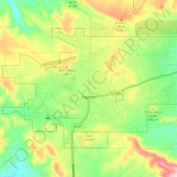
Name: Payson topographic map, elevation, terrain.
Location: Payson, Gila County, Arizona, 85072, United States (34.21706 -111.37054 34.27176 -111.27319)
Average elevation: 1,522 m
Minimum elevation: 1,379 m
Maximum elevation: 1,725 m
Make a donation
Other topographic maps
Click on a map to view its topography, its elevation and its terrain.
Make a donation
Make a donation
Star Valley
United States > Arizona > Gila County > Star Valley
According to the United States Census Bureau, the town has a total area of 36.1 square miles (93.6 km2), of which 0.01 square miles (0.02 km2), or 0.03%, is water. Star Valley sits at an elevation of 4,650 feet (1,420 m) and takes its name from the valley in which it is located, formed by Houston Creek, which…
Average elevation: 1,521 m
Make a donation